Amazfit T-Rex 3 is a fully-featured smartwatch, especially for outdoor enthusiasts. Its features include downloading and using offline maps. Leading in class with the tough 1.5-inch AMOLED panel and brilliant 2,000 nits of luminance, T-Rex 3 can serve very well while navigating harsh conditions.
This makes it a great tool for hiking, skiing, or any other kind of activity for which network connectivity may not be all that reliable.
Herein, we will show How to Download and Use Offline Maps on the Amazfit T-Rex 3 and how to use them effectively.
How to Download Maps to the Amazfit T Rex 3
Step 1: Prepare Your Device and App

Before downloading, let’s ensure that the watch is properly connected in the Zepp Health app. This will help handle all settings for Amazfit T Rex 3 and download all the other apps.
Here’s where you get started:
- Open the Zepp Health application on your smartphone.
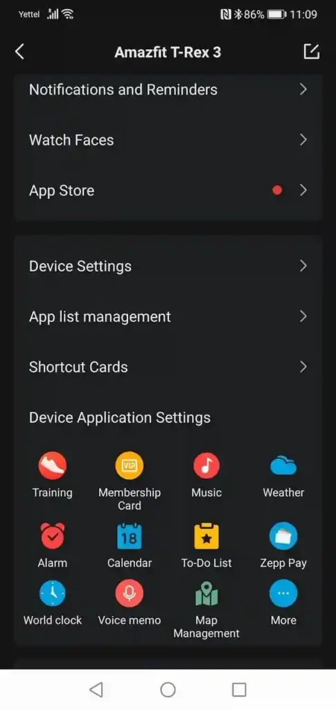
- Open the Profile tab and select your Amazfit T-Rex 3 from the list of connected devices.
- Scroll down and there you will find the option of Map Management.
Step 2: Map Download Endorsement

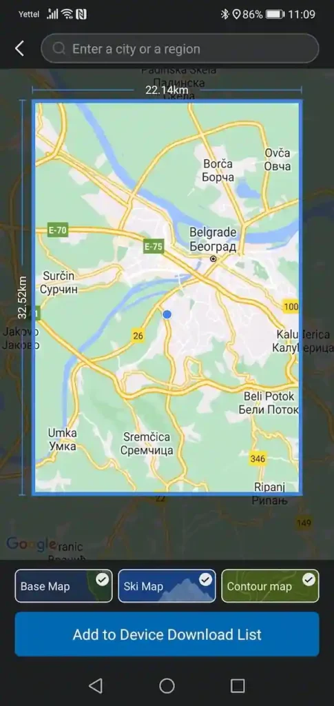
Once you open the Zepp app’s Map Management section, it will automatically choose a default map for your current area (32.5 by 22.14 km), though you’re free to scroll around and choose different regions or set custom ones.
Pick and download:
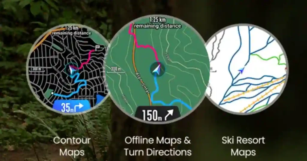
- Choose a style: Base, Ski, Contour—or any combination.
- Type in the search box when you don’t want the default area.
- You can check on the title and click on Add to Device Download List.
Step 3: Download Maps to Your Watch
Note: Make sure your TRex 3 has been connected to Wi-Fi before attempting to download the app. If you haven’t already, go through the following steps:
- Tap the watch settings.
- Click on the tab for Connection Management, and then under the available networks, click on your Wi-Fi.
- You need to enter the WiFi password from your phone into an application called Zepp.
If Wi-Fi is configured on your watch, then when it is established, the watch itself will automatically ask you if you want to download from the device list. Generally, downloading takes approximately 5 minutes as per your connection. The watch will take approximately another minute to unpack the downloaded file.
How to Use Offline Maps on the Amazfit T-Rex 3

Once you have the maps downloaded, viewing the map information on Amazfit T-Rex 3 is a cakewalk. There are two main ways that you can access it:
Using offline maps on the Amazfit T-Rex 3 involves a few steps, which include downloading maps onto your device and using them without an internet connection during outdoor activities such as hiking or running. Here’s how you can do it:
1. Ensure Your Amazfit T-Rex 3 is Updated
Before starting, make sure your watch has the latest firmware update. You can check this in the Zepp app (formerly Amazfit app), which is used to manage and sync your Amazfit T-Rex 3.
2. Install the Zepp App
To manage your Amazfit T-Rex 3, install the Zepp app on your smartphone. The app is available on both Google Play Store (for Android) and Apple App Store (for iOS).
Once installed, pair your watch with the app via Bluetooth.
3. Activate GPS on the Watch
Ensure GPS is activated on your T-Rex 3. Go to your watch’s Settings, then find GPS Mode and activate it. This is essential for using offline maps and tracking your location.
4. Download Maps (If Supported)
Not all Amazfit devices support direct offline map downloads. However, some models like the T-Rex 3 might support it via third-party apps or integrations.
Thanx for the Amazfit T-Rex 3 supports offline maps, there will be a section in the Zepp app or a related third-party app to download specific regions for offline use. The process generally involves:
- Choosing a region or route in the app.
- Downloading the map data to your watch through the app sync.
5. Use a Third-Party App (If Needed)
If the T-Rex 3 doesn’t have a built-in offline map feature, you can use third-party apps like Strava, Komoot, or GPX Viewer, which allow you to plan routes on your phone, download them, and sync them with your watch. Here’s how:
- Plan a route in a third-party app like Komoot or Strava.
- Export the route as a GPX file (a standard GPS file format).
- Sync the GPX file to the watch through the Zepp app or a supported third-party service.
- Once synced, you can access the route on your watch for offline navigation.
6. Access Offline Maps
On the watch, navigate to the Route or Navigation feature (this will depend on the firmware version or third-party integration). Select the downloaded map or GPX route.
Start your outdoor activity (hiking, cycling, running), and the watch will guide you using the pre-loaded map or route, even if you’re offline.
7. Track and Follow the Route
During your activity, the watch will display your position and allow you to follow the saved route or map without requiring an internet connection. The GPS in the watch will work offline to track your location.
8. Turn-by-Turn Navigation (If Available)
Some apps or routes may provide turn-by-turn navigation on your watch. This feature will guide you through your pre-loaded map route, giving you alerts when you need to make turns.
Tips:
Battery Life: GPS can drain the battery quickly, so ensure your watch is fully charged before going out. You can adjust the GPS mode to save battery life if needed.
Compass Calibration: Ensure the watch’s compass is properly calibrated before you start using the map for accurate navigation.
Update Maps: Regularly update offline maps in case new routes or areas are added.
By following these steps, you can effectively use offline maps on your Amazfit T-Rex 3 for outdoor activities.
Mapping Interactions and Contexts
There are some serious interactions and settings to be aware of with this:
Zooming: Use the + and – icons on the map interface. The zoom can be adjusted using the left-handed buttons on the watch.
Map Settings: At the upper right, one can tap a button that reveals settings. From there, a setting can be changed to be either a light or dark mode.
There is an auto-mode, though, since it will determine the best brightness to use based on your environment. The dark mode is suitable for nighttime, while the white one works best under bright outdoor settings.
Exit the Map: To exit this mode, just swipe right or use the back button on your watch.
Conclusion
The Amazfit TRex 3 offers advanced mapping capabilities for users who enjoy the outdoors. By downloading offline maps, you can navigate confidently without needing a data connection. Whether you’re skiing, hiking, or exploring a new city, the TRex 3’s GPS and map features will keep you on the right path.
With its bright display, glove mode, and easy to use mapping tools, the Amazfit T Rex 3 stands out as one of the best smartwatches for navigation and outdoor use. Make sure you follow the steps in this guide to take full advantage of the T Rex 3’s mapping capabilities.
q. What is an offline map on Amazfit T -Rex 3
The offline map feature on the Amazfit T-Rex 3 allows you to access and use maps without needing an active internet connection. This is particularly useful for outdoor activities like hiking, running, or traveling in areas where cellular or Wi-Fi signals may be weak or unavailable.
Here’s how it works:
Preloading Maps: Before you head out, you can preload specific map areas onto your Amazfit T-Rex 3 using the Zepp app (the companion app for the watch). This typically involves selecting the region or route you plan to navigate.
Navigation and Tracking: Once the maps are loaded onto your watch, you can use them for navigation and tracking during your activities. The watch will use GPS to track your location and display it on the offline map.
Route Planning: You can also plan routes and set waypoints, which will be saved on the watch for offline use.
Data Usage: Since the maps are stored locally on the watch, you won’t need an internet connection to access them, which saves on data usage and ensures you have reliable navigation in remote areas.
Overall, this feature enhances the usability of the Amazfit T-Rex 3 for outdoor enthusiasts who need navigation support without relying on network connectivity.
q. What is the difference between offline maps and online maps?
Offline maps are preloaded onto your device and can be used without an internet connection. They are ideal for areas with poor or no signal and help avoid data charges. However, they may not update in real-time and can take up storage space on your device. In contrast, online maps require an internet connection to access and provide real-time updates and dynamic information. While they offer current details and live traffic updates, they depend on a stable data connection and use mobile data.

